
Aomori City Tsunami Hazard Map (English)
About the Tsunami Hazard Map
In April 2020, the Cabinet Office released “A Model for a Megaquake Along the Japan and Chishima Trench.” Based off of that document, Aomori Prefecture conducted their own independent simulation for the region and in May 2021, made available a handbook which contains a new tsunami inundation prediction.
Learning of this, Aomori City updated its own Tsunami Hazard Map which contains disaster prevention information for tsunamis and the flooding caused by them.
It is important that everyone be aware of how to prepare for disasters and that they regularly take steps to prepare in order to keep the damage caused by tsunamis to a minimum. Use this Tsunami Hazard Map to discuss with your family and your community where you will evacuate to and the route you will take during a disaster before one strikes.
About the Tsunami Hazard Map
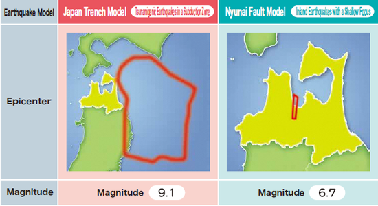
The Tsunami Hazard Map was updated to include an earthquake model for the Japan Trench, where earthquakes take place in a subduction zone. This model was added to the already existing earthquake model for the Nyunai Fault where earthquakes with a shallow fault take place inland. Information about these two types of tsunami which have differing characteristics, the time it takes for the tsunamis to strike, the height of the tsunamis, and the areas that are predicted to be flooded by the two tsunamis are compared, and the proper way to evacuate is easily explained.
What is Included in the Tsunami Hazard Map
The Areas Predicted to be Inundated by a Tsunami and Tsunami Heights
-
Areas Predicted to be Inundated by a Tsunami
-
Tsunami Heights
Information Related to Tsunamis That Should Heeded
-
Characteristics of Tsunamis
-
Characteristics of Tsunamis that Affect Aomori City
-
Inundation Depths
-
Tsunami-related Information
-
How to Prevent Causalities in a Tsunami
-
How to Prepare for Disasters and Other Relevant Information
List of Evacuation Shelters and Sites
The names and addresses of the Combined Designated Emergency Evacuation and Designated General Evacuation Sites and Shelters, Designated Emergency Evacuation Sites, and Designated Social Welfare Evacuation Shelters in Aomori City
How the Aomori City Hazard Map is Made Available
-
You can receive a copy of the Aomori City Hazard Map by visiting Aomori City Hall (Crisis Management Section, Honcho Building/ General Affairs Section, Namioka Building)
-
A digital copy of the Aomori City Hazard Map is also available below in PDF form.
Note
In the event that the focus, scale, and other conditions of an earthquake differ, a tsunami larger than one predicted in this Tsunami Hazard Map may occur; areas outside of the anticipated inundation area may be flooded; and the arrival of a tsunami may be faster than anticipated. People in coastal areas should exercise additional caution.
添付ファイル
-
Front Cover/Back Cover Table of Contents Earthquake Models Our Disaster Preparedness Plan How to Contact Others in an Emergency (PDF 262.3KB)

-
Characteristics of Tsunamis Characteristics of Tsunamis that Affect Aomori City P1-P2 (PDF 385.6KB)
-
Inundation Depths Tsunami-related Information P3-P4 (PDF 392.5KB)
-
How to Prevent Causalities in a Tsunami How to Prepare for Disasters P5-P6 (PDF 351.8KB)
-
Reference Map for All Aomori City Maps Japan Trench Model Maps(Tsunamigenic Earthquake in a Subduction Zone) P7-P8 (PDF 2.6MB)
-
Reference Map for All Aomori City Maps Nyunai Fault Model Maps(Shallow Hypocentered Inland Earthquake) P9-P10 (PDF 2.5MB)
-
Map 1 【Japan Trench/Nyunai Fault】 Shitobashi/Rokumaibashi Area P11-P12 (PDF 1.7MB)
-
Map 2 【Japan Trench/Nyunai Fault】 Uchimanbe/Setoshi Area P13-P14 (PDF 1.8MB)
-
Map 3 【Japan Trench/Nyunai Fault】 Setoshi/Nishitazawa Area P15-P16 (PDF 1.8MB)
-
Map 4 【Japan Trench/Nyunai Fault】 Nishitazawa/Aburakawa Area P17-P18 (PDF 2.0MB)
-
Map 5 【Japan Trench】 Shinmachi/Honcho Area P19-P20 (PDF 1.5MB)
-
Map 5 【Nyunai Fault】 Shinmachi/Honcho Area P21-P22 (PDF 1.3MB)
-
Map 6 【Japan Trench】 Tsukurimichi/Harabetsu Area P23-P24 (PDF 1.5MB)
-
Map 6 【Nyunai Fault】 Tsukurimichi/Harabetsu Area P25-P26 (PDF 1.2MB)
-
Map 7 【Japan Trench/Nyunai Fault】 Nonai Area P27-P28 (PDF 1.8MB)
-
Map 8 【Japan Trench/Nyunai Fault】 Nonai/Kugurizaka Area P29-P30 (PDF 1.7MB)
-
Map 9 【Japan Trench/Nyunai Fault】 Kugurizaka Area P31-P32 (PDF 1.7MB)
-
Map 10 【Japan Trench/Nyunai Fault】 Asamushi Area P33-P34 (PDF 1.8MB)
-
Map 11 【Japan Trench】 Central Aomori City (The Area Around Aomori Central Hospital) P35-P36 (PDF 1.5MB)
-
List of Evacuation Shelters and Sites P37-P38 (PDF 174.3KB)
PDFファイルの閲覧には「Adobe Acrobat Reader(R)」をアドビシステムズ社サイト(新しいウィンドウ)からダウンロード(無料)してください。
このページに関するお問い合わせ
青森市総務部危機管理課
〒030-8555 青森市中央一丁目22-5 本庁舎2階
電話:017-734-5059 ファックス:017-734-5061
お問合せは専用フォームをご利用ください。