

ホーム > 安全・緊急 > 防災・消防 > 「リスク」を知る > 各種ハザードマップ等 > 青森市津波ハザードマップ > Aomori City Tsunami Hazard Map (English)
ここから本文です。
更新日:2023年7月20日
Aomori City Tsunami Hazard Map (English)
In April 2020, the Cabinet Office released “A Model for a Megaquake Along the Japan and Chishima Trench.” Based off of that document, Aomori Prefecture conducted their own independent simulation for the region and in May 2021, made available a handbook which contains a new tsunami inundation prediction.
Learning of this, Aomori City updated its own Tsunami Hazard Map which contains disaster prevention information for tsunamis and the flooding caused by them.
It is important that everyone be aware of how to prepare for disasters and that they regularly take steps to prepare in order to keep the damage caused by tsunamis to a minimum. Use this Tsunami Hazard Map to discuss with your family and your community where you will evacuate to and the route you will take during a disaster before one strikes.
About the Tsunami Hazard Map
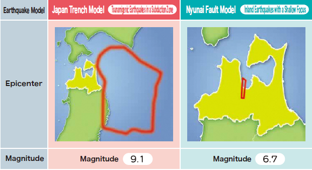
The Tsunami Hazard Map was updated to include an earthquake model for the Japan Trench, where earthquakes take place in a subduction zone. This model was added to the already existing earthquake model for the Nyunai Fault where earthquakes with a shallow fault take place inland. Information about these two types of tsunami which have differing characteristics, the time it takes for the tsunamis to strike, the height of the tsunamis, and the areas that are predicted to be flooded by the two tsunamis are compared, and the proper way to evacuate is easily explained.
What is Included in the Tsunami Hazard Map
The Areas Predicted to be Inundated by a Tsunami and Tsunami Heights
- Areas Predicted to be Inundated by a Tsunami
- Tsunami Heights
Information Related to Tsunamis That Should Heeded
- Characteristics of Tsunamis
- Characteristics of Tsunamis that Affect Aomori City
- Inundation Depths
- Tsunami-related Information
- How to Prevent Causalities in a Tsunami
- How to Prepare for Disasters and Other Relevant Information
List of Evacuation Shelters and Sites
- The names and addresses of the Combined Designated Emergency Evacuation and Designated General Evacuation Sites and Shelters, Designated Emergency Evacuation Sites, and Designated Social Welfare Evacuation Shelters in Aomori City
How the Aomori City Hazard Map is Made Available
- You can receive a copy of the Aomori City Hazard Map by visiting Aomori City Hall (Crisis Management Section, Honcho Building/ General Affairs Section, Namioka Building)
- A digital copy of the Aomori City Hazard Map is also available below in PDF form.
Note
In the event that the focus, scale, and other conditions of an earthquake differ, a tsunami larger than one predicted in this Tsunami Hazard Map may occur; areas outside of the anticipated inundation area may be flooded; and the arrival of a tsunami may be faster than anticipated. People in coastal areas should exercise additional caution.
![]()
PDF形式のファイルをご覧いただく場合には、Adobe Acrobat Readerが必要です。Adobe Acrobat Readerをお持ちでない方は、バナーのリンク先から無料ダウンロードしてください。
問合せ
より良いウェブサイトにするために皆さんのご意見をお聞かせください。